
![[PODCAST] Corvette News and Headlines with CorvetteBlogger on the Corvette Today Podcast](https://steinews.com/wp-content/uploads/2025/08/PODCAST-Corvette-News-and-Headlines-with-CorvetteBlogger-on-the-Corvette.jpg)


Now Reading: NOAA Hurricane Erin forecasts dangers on beaches along East Coast
-
01
NOAA Hurricane Erin forecasts dangers on beaches along East Coast
NOAA Hurricane Erin forecasts dangers on beaches along East Coast
Dozens of hurricanes have made a similar trek in recent years, testing the nerves of millions who wait to see if the storms are destined to make any sharp left turns or wobbles toward the coast.

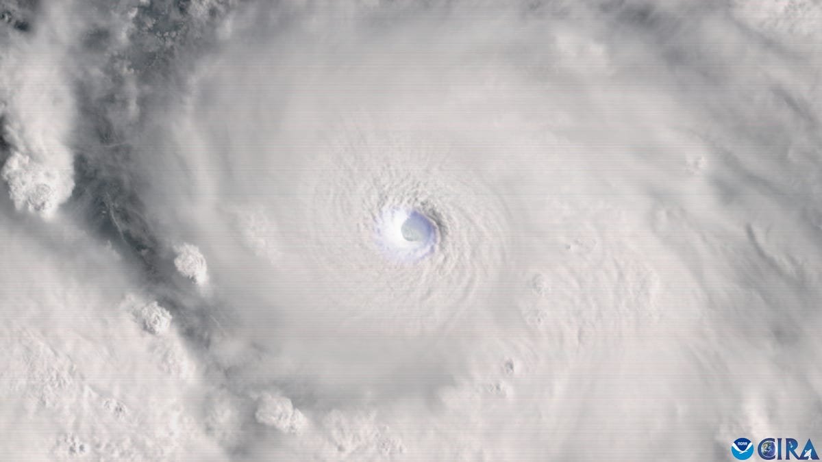
NOAA hurricane hunters capture Hurricane Erin’s eye over Atlantic
NOAA and Air Force hurricane hunters captured stunning footage inside Hurricane Erin’s eye over the Atlantic Ocean.
Hurricane Erin, with powerful winds of more than 160 mph on August 16, is expected to take a path familiar to many as the massive storm moves northward parallel to the United States coast.
Dozens of hurricanes have made a similar trek in recent years, testing the nerves of millions who wait to see if the storms are destined to make any sharp left turns or wobbles toward the coast. Even when they don’t brush the coast or make landfall, such storms can be deadly and cause millions of dollars of damage.
Erin is expected to remain hundreds of miles offshore, according to the National Hurricane Center, part of the National Weather Service. As of 5 p.m. Aug. 16, Erin is forecast to be centered roughly 600 miles east of Savannah on Aug. 20.
But because Erin is growing both in size and intensity, chances are increasing that it will still create rough conditions at sea and along beaches as it moves northward off the coast, the weather service says.
Many lives have been lost during hurricanes that remained well offshore but created rough surf or deceptive conditions that can disguise hazardous rip currents. Over a 10-year period, about 10 to 15% of all deaths in tropical storms and hurricanes were attributed to rip currents, according to the hurricane center. That’s one reason behind a new public safety campaign NOAA launched earlier this year – “Blue IQ.”
Erin and past storms also clearly demonstrate how dependent we are on overhead weather patterns to steer tropical storms and hurricanes away from the coast. Examples of these patterns include the jet stream and a ridge of high pressure over the Atlantic Ocean, known as the Bermuda High.
What’s the chance Erin could veer closer to the coast?

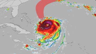
Eastern U.S. could see impacts from Hurricane Erin
While Hurricane Erin will pass to the east of the U.S., we could still see impacts. Tropical storm force winds extend 200 miles from the center of the storm, as Erin continues to grow in size.
The Weather Channel
While the paths of many previous hurricanes have made wobbles or turns toward the coast, as Superstorm Sandy did in 2012, it’s unlikely in this case, forecasts say.
The hurricane center’s skill at predicting storms – especially large, well-formed hurricanes – has improved significantly in recent years. That’s thanks in part to the years of federal science data that have been collected and fed into computer models that assist the center’s hurricane specialists in plotting forecasts.
The weather service, including the hurricane center, “has done a pretty darned good job over the last five years of predicting the path of storms,” said Rob Young, director of the program for the study of developed shorelines, a joint venture with Duke and Western Carolina universities.
In March 2025, the hurricane center announced its 2024 track forecast performance was the best in its history.
Through Aug. 21, the locations along the U.S. East Coast with the greatest risks of tropical storm force winds are Nantucket, Massachusetts, and Cape Hatteras, North Carolina, where the center lists the risk at 6%. Cape Hatteras has only a 1% chance of experiencing hurricane-force winds and both locations have only a 1% chance of hurricane-force winds.
‘Storms like this can be beach eaters’
Because Erin is growing in size, it’s increasing the risks for coastal erosion, rip currents and hazardous conditions at the coast, the weather service said. Meteorologists are already warning beachgoers and mariners to pay attention to conditions and forecasts as Erin approaches the offshore waters.
The hurricane center warns Erin’s swells are expected to affect portions of the northern Leeward Islands, the Virgin Islands, Puerto Rico, Hispaniola and the Turks and Caicos through August 17. Swells are then expected to spread into the Bahamas, Bermuda and the U.S. East Coast by August 18 and are likely to create life-threatening surf conditions and rip currents.
“These storms that stay offshore like this one is expected to do can still impact over 1,000 miles of coast with waves and a little storm surge,” Young said. “They’re unlikely to knock down homes, unless those homes are already in the water.” Such at-risk homes could include structures in southern St. Johns County on Florida’s east coast and homes on a section of North Carolina’s Outer Banks.
“Storms like this can be beach eaters,” Young said. “Storms like this can really chew up the sand,” including on renourished beaches, even if the storms never come ashore, he said. “Erin may still do what some folks would call damage to the beaches on the order of tens of millions of dollars.”
Which storms took a path similar to Hurricane Erin?
Dozens of storms have traveled north offshore, often curving completely away from the coast without making landfall in the mainland United States or in Canada, but some leave damage in their wakes, in the form of erosion, coastal flooding and even deaths from rough seas. These are some of the more notable storms:
Hurricane Erin: The last time there was a Hurricane Erin was in September 2001. That Erin also traveled a northward path, farther offshore. A NASA satellite photo of the massive hurricane swirling offshore east of North Carolina and Virginia on September 11, 2001, also showed smoke trailing from the site of the attacks on the World Trade Center’s twin towers.
Hurricane Bill: In August 2009, even though the hurricane was offshore of the U.S, two people died in large waves and rough seas: a 7-year-old girl in Acadia National Park in Maine and a 54-year-old in New Smyrna Beach, Florida, according to the hurricane center’s after-storm report. The strong surf led to multiple rescues along the coast, as well as coastal flooding. The hurricane later made landfall in Newfoundland.
Hurricane Joaquin: Joaquin looped in the Bahamas in late September and early October of 2015, and then traveled northeast. After sailing into Joaquin, the SS El Faro was lost at sea on Oct. 1 and ultimately sunk, killing 33 crew members. A weather system that developed over the Southeast tapped into a steady stream of moisture from Joaquin and created days of rain, while high tides from the hurricane’s swells all combined to cause historic flooding in South Carolina, including in Columbia and Charleston, even though the hurricane remained offshore.
Hurricane Lorenzo: Like Erin, 2019’s Hurricane Lorenzo rapidly intensified and became a major hurricane. Even though it was centered much farther to the east in the Atlantic, Lorenzo created massive swells that caused “hazardous surf and rip currents along U.S. beaches for several days,” the hurricane center said. Eight people died in the storm’s rough surf and rip currents, four in North Carolina, one in Florida, two in New York and one in Rhode Island.
What’s a ‘fish storm?’
Many hurricane veterans jokingly refer to hurricanes and tropical storms that remain offshore as “fish storms,” because they remain over the open ocean. However, Brian LaMarre, a veteran meteorologist who recently retired from the weather service, said this week there’s “a great deal more than fish out there” given the dense shipping traffic and commerce networks offshore.
Impacts from the waves and long-period swells can be “incredibly disruptive and can extend hundreds of miles outward from these ocean storm systems,” LaMarre said.
Track Erin’s progress
Dinah Voyles Pulver covers climate change and the environment for USA TODAY. She’s written about hurricanes, tornadoes and violent weather for more than 30 years. Reach her at dpulver@usatoday.com or @dinahvp on Bluesky or X or dinahvp.77 on Signal.


Related Posts


Stay Informed With the Latest & Most Important News
Previous Post
Next Post
Previous Post

Next Post


Advertisement


