


Now Reading: Another hot one today, but relief is on the way
-
01
Another hot one today, but relief is on the way
Another hot one today, but relief is on the way
What We’re Tracking
-
Heat continues into Monday
-
Comfortable weather ahead
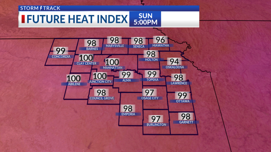
The summer-like stretch continues into today, with highs holding in the middle 90s, heat indices around 100°-105°. Over the next few days, remember to stay cool, stay hydrated, limit outdoor activities, and try to stay in the shade as much as possible.

We’re still holding onto the heat as we begin the new work week with highs in the middle 90s and heat indices closer to 105° possible for all of northeastern Kansas. Clouds will begin to increase ahead of a few scattered shower and storms Monday afternoon. The better chance for storms come Monday night into early Tuesday morning.

Relief returns Tuesday throughout the rest of the week. Another round of storms possible Tuesday afternoon/evening allowing temperatures to drop into the upper 80s for a much more comfortable rest of the week.
KSNT Storm Track Meteorologist Evan Biedron
Copyright 2025 Nexstar Media, Inc. All rights reserved. This material may not be published, broadcast, rewritten, or redistributed.
For the latest news, weather, sports, and streaming video, head to KSNT 27 News.


Related Posts


Stay Informed With the Latest & Most Important News
Previous Post
Next Post
Previous Post

Next Post


Advertisement


