


Now Reading: canyon lake flooding: Canyon Lake level today: Is the Guadalupe River inching towards flooding? What we know about the overflow point
-
01
canyon lake flooding: Canyon Lake level today: Is the Guadalupe River inching towards flooding? What we know about the overflow point
canyon lake flooding: Canyon Lake level today: Is the Guadalupe River inching towards flooding? What we know about the overflow point

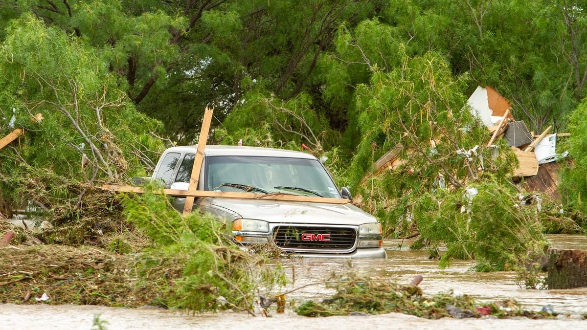
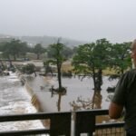
Canyon Lake, located in Comal County, serves as a crucial flood-control reservoir for the area. However, with water levels rising rapidly due to persistent rainfall, concerns about possible dam spillage and downstream impact are mounting.
Lake Nears Halfway Mark to Spillage Level
As of Saturday morning, officials confirmed that Canyon Lake water level stands a little over halfway to its designated flood spillage threshold. The U.S. Army Corps of Engineers, responsible for managing the dam, stated that there remains approximately 66 feet of capacity before water reaches the overflow point.
Fortunately, weather forecasts have offered a reprieve, with rain showers now shifting south of the dam. This geographic shift could help reduce additional inflow from upstream sources, thereby easing pressure on the lake’s rising levels, as per a report by Hindustan Times.
Despite this temporary relief, authorities continue to urge caution, especially given the unpredictable nature of weather systems during the peak of Texas’ flood season.

Floods Claim Lives, Prompt Emergency Response
The Guadalupe River flooding has already led to tragic consequences. At least six fatalities have been reported across Kerr County and adjacent areas within the Texas Hill Country. Emergency services remain active in several pockets, conducting search-and-rescue operations and facilitating evacuation efforts.In response to the growing crisis, local officials have advised residents living near riverbanks or in low-lying areas to evacuate to higher ground. Temporary shelters have been activated, and emergency alerts continue to be broadcast through radio, social media, and local news outlets.
Camps Along River Affected; Search Operations Underway
The flooding has severely impacted recreational and camping areas along the riverbanks. Reports from Hunt, Texas, suggest that multiple campers—mainly children—have gone missing after the rising river overwhelmed popular summer camps.
Institutions such as Camp La Junta, Camp Waldemar, and Mystic River Camp have issued public statements acknowledging that several of their young campers remain unaccounted for. Rescue units, including local police, fire departments, and the Texas Department of Public Safety, have launched coordinated search operations across affected regions.
“Swift-water rescue teams are on standby, and we are working closely with camp officials to verify all individuals’ safety,” stated a spokesperson for the Texas Parks and Wildlife Department.
Drought-Hit Region Unprepared for Sudden Inundation
Ironically, the same areas now facing severe flooding had been suffering from prolonged drought conditions for much of the year. Water bodies like Canyon Lake and Medina Lake had reported below-average levels until the recent deluge dramatically changed the scenario.
Due to this prior deficit, reservoirs in Central Texas—including Canyon Lake—have relatively low flood spillage thresholds, making them more vulnerable to sudden increases in water levels. Experts note that while dams such as Canyon are designed to manage fluctuations, the intensity of this event has pushed infrastructure close to capacity.
“The lake was not full going into this storm, which helped, but the inflow over the past 24 hours has been substantial,” said a hydrologist affiliated with the Texas Water Development Board.
What Comes Next?
Meteorological agencies are keeping a close watch on upcoming weather patterns, particularly across the Guadalupe River Basin. While rainfall has tapered off in the immediate vicinity of Canyon Dam, new storms are forecast for southern Texas, which could further impact downstream conditions.
Authorities continue to assess the structural integrity of the dam, which so far shows no signs of compromise. However, community leaders stress the need for residents to remain vigilant.
“We are cautiously optimistic, but we’re not out of danger yet,” warned a senior official from Comal County’s Emergency Management Department. “People must listen to local advisories and avoid traveling near flooded zones.
FAQs
Where is Canyon Lake located and why is it significant?
Canyon Lake is located in Comal County, Central Texas. It is a critical flood-control reservoir formed by Canyon Dam along the Guadalupe River. It helps regulate water flow and prevent downstream flooding during heavy rains.
Has the risk of overflow at Canyon Dam increased?
Yes, due to persistent and heavy rainfall, the risk of spillage has increased. However, forecasts now show rain moving south of the dam, potentially reducing further inflow and easing immediate pressure.


Related Posts
Stay Informed With the Latest & Most Important News
Previous Post
Next Post


Advertisement