


Now Reading: Forecast to strengthen into 1st Atlantic hurricane of 2025 later today, latest projected path prompts watches for northern Leeward Islands
-
01
Forecast to strengthen into 1st Atlantic hurricane of 2025 later today, latest projected path prompts watches for northern Leeward Islands
Forecast to strengthen into 1st Atlantic hurricane of 2025 later today, latest projected path prompts watches for northern Leeward Islands

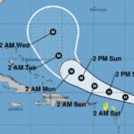
Tropical Storm watches are now in effect for parts of the northern Leeward Islands as Erin is expected to become the first hurricane of the 2025 Atlantic hurricane season later today, according to forecasters at the National Hurricane Center.
Erin formed in the eastern Atlantic Ocean on Monday and is steadily strengthening as it moves westward. The NHC said there is still uncertainty about what impact it could have on states like Florida on the U.S. East Coast, as well as the Bahamas and Bermuda.
But forecasters remain confident that Erin “will be a large and powerful hurricane over the southwestern Atlantic Ocean this weekend.”
Where is Tropical Storm Erin, and what is its path?
As of 8 a.m. ET Friday:
-
Erin was located 520 miles east of the northern Leeward Islands.
-
The storm has maximum sustained winds of 70 mph.
-
It is moving west-northwest at 17 mph.
The storm is expected to continue moving west-northwest into the weekend. “The center of Erin is likely to move near or just north of the northern Leeward Islands over the weekend,” the NHC said.
The storm is expected to bring areas of heavy rainfall starting late Friday across the northern Leeward Islands, the U.S. and British Virgin Islands, as well as southern and eastern Puerto Rico. Rainfall totals could range from 2 to 4 inches, with up to 6 inches in isolated areas, which could lead to flash or urban flooding and cause mudslides and landslides, the hurricane center said Friday.
What are the chances it will intensify?
Tropical Storm Erin is expected to become a hurricane later today, forecasters said, adding that it could become a major hurricane by this weekend.
A tropical storm becomes a hurricane when maximum sustained winds reach at least 74 mph. Hurricanes are rated on the Saffir-Simpson Hurricane Wind Scale, ranging from Category 1 to Category 5, with 5 being the most severe. A storm is considered a major hurricane when it reaches Category 3 strength, with sustained winds of at least 111 mph, according to the NHC.
Watches and warnings in place
As of 8 a.m. ET Friday, these are the following advisories in place, according to the NHC:
Tropical storm watch in effect for:
-
St. Martin and St. Barthelemy
A “tropical storm watch” means tropical storm conditions are possible in the areas within the next 48 hours.
How is hurricane season shaping up?
The 2025 Atlantic hurricane season, which began June 1 and runs through the end of November, has a 50% chance of being above normal.
Last week, forecasters at the National Oceanic and Atmospheric Administration slightly updated the number of expected storms to 13-18 (estimated at 13-19 in May), five of which could become major hurricanes (with winds of more than 111 mph).
A typical hurricane season averages 14 named storms. We’re currently about halfway through this year’s hurricane season, and there have been five so far: tropical storms Andrea, Barry, Chantal, Dexter and Erin.


Related Posts

Stay Informed With the Latest & Most Important News
Previous Post
Next Post


Advertisement


