


Now Reading: How Hurricane Erin’s path threatens South Florida with dangerous rip currents, high surf
-
01
How Hurricane Erin’s path threatens South Florida with dangerous rip currents, high surf
How Hurricane Erin’s path threatens South Florida with dangerous rip currents, high surf

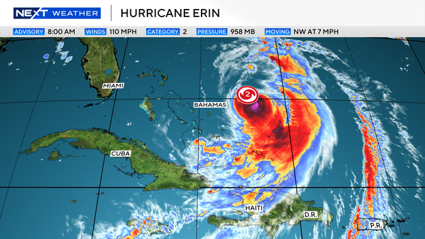
Hurricane Erin remained a large and dangerous storm as it moved near the Bahamas on Tuesday morning, but the NEXT Weather team stressed no direct impacts are expected for South Florida.
South Florida and U.S. East Coast residents, however, should brace for indirect effects, including higher surf and a heightened rip current risk over the next several days.
As Erin shifts north, winds along South Florida’s coastline will turn from the north, bringing a high rip current risk Tuesday that may linger until Thursday. Surf could rise up to 6 feet, especially along Palm Beach County. No official marine alerts have been issued.
Although there are no alerts or advisories for boaters along the Atlantic waters yet, marine conditions will deteriorate over the next few days as winds increase and wave heights rise 2 to 5 feet due to large swells from Erin.
Tracking Hurricane Erin
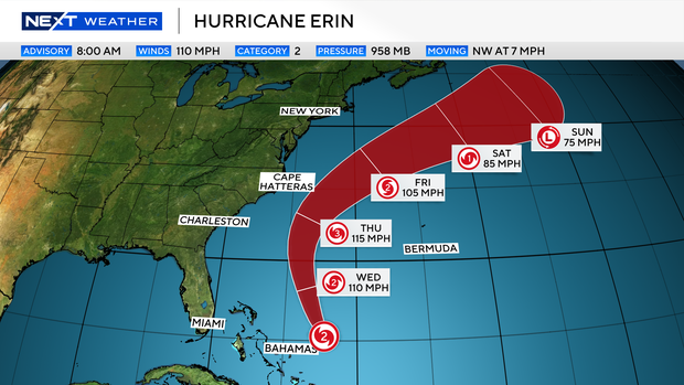
As of the 8 a.m. advisory from the National Hurricane Center, Erin’s maximum sustained winds are 110 mph and it is moving northwest at 7 mph.
Hurricane-force winds extend outward up to 80 miles from the center, while tropical-storm-force winds reach as far as 205 miles.
Heavy rainfall from the outer bands of Erin will continue Tuesday for the Turks and Caicos and through Tuesday night for the Bahamas. Flash and urban flooding are possible.
Hurricane Erin’s projected path
Ering is expected to take a turn toward the north-northwest on Tuesday and is not forecast to make landfall on the east coast of the U.S.
Erin will pass to the east of the Bahamas on Tuesday and then move over the western Atlantic between the U.S.east coast and Bermuda on Wednesday and Thursday.
North Carolina under tropical storm and surge watches
The heaviest impacts in the U.S. are expected along the North Carolina coastline and Outer Banks, where a tropical storm watch, storm surge watch, and high surf advisory remain in effect through midweek. Surge up to 4 feet and waves as high as 20 feet are possible.
Erin is forecast to shift northeast around Thursday and move further away from the U.S. into the Atlantic.
The NEXT Weather team will continue to monitor updates from the NHC and track the latest model trends.


Related Posts


Stay Informed With the Latest & Most Important News


Advertisement


