


Now Reading: Tropical Storm Erin spaghetti models, tracker, path
-
01
Tropical Storm Erin spaghetti models, tracker, path
Tropical Storm Erin spaghetti models, tracker, path
Erin expected to become the first major Atlantic hurricane of 2025
By August 18, Erin will likely be a hurricane off the Southeast coast of the U.S., so now is the time to prepare.
- Tropical Storm Erin is beginning to strengthen.
- Erin is expected to become a hurricane Friday, Aug. 15.
- The current forecast predicts Erin will become a very strong Category 3 storm, with maximum sustained winds of 125 mph within five days.
- While Erin currently is forecast to stay away from Florida, now is the time to prepare for a storm.
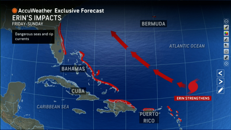
Tropical Storm Erin is beginning to strengthen and is expected to become a hurricane by Friday afternoon and a major hurricane by Sunday morning, Aug. 17, according to the latest advisory from the National Hurricane Center.
The current forecast predicts Erin will become a very strong Category 3 storm, with maximum sustained winds of 125 mph within five days.
A major hurricane is one that’s a Category 3 or higher, with maximum sustained winds of at least 111 mph.
➤ Track all active storms
➤ Weather alerts via text: Sign up to get updates about current storms and weather events by location
While Erin is predicted to curve north before reaching Florida and the United States, impacts along the coast are possible, especially dangerous surf and rip currents.
Officials are encouraging residents to monitor the storm closely and to make sure they’re prepared.
➤ Don’t have a hurricane supply kit? From the basics to the extras, here’s what you need
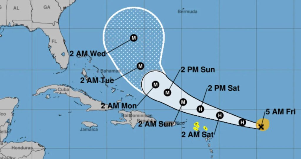
Where is Tropical Storm Erin going?
Special note on the NHC cone: The forecast track shows the most likely path of the center of the storm. It does not illustrate the full width of the storm or its impacts, and the center of the storm is likely to travel outside the cone up to 33% of the time.
Tropical Storm Erin spaghetti models
Special note about spaghetti models: Illustrations include an array of forecast tools and models, and not all are created equal. The hurricane center uses only the top four or five highest performing models to help make its forecasts.
➤ Track Tropical Storm Erin
➤ How often has Florida been impacted, threatened by August hurricanes? We took a look back
Tropical Storm Erin storm tracker, path
Satellite view of Tropical Storm Erin
Track all active Atlantic storms and disturbances
What should you do now to prepare for hurricane season?
Officials regularly encourage Florida residents to prepare for storms before a hurricane is approaching while shelves are full stocked and you aren’t battling crowds all rushing to the store at the same time.
➤ Don’t have a hurricane supply kit? From the basics to the extras, here’s what you need
“It only takes one storm to make it an impactful year for your community,” the National Hurricane Center Miami posted on X. “Hurricane season is a marathon, not a sprint.”
On Aug. 1, specific hurricane supplies became permanently tax free in Florida, ranging from batteries to generators.
➤ See list of emergency supplies you can now buy tax free
Florida weather radar for Aug. 14, 2025
Weather watches and warnings issued in Florida
When is the Atlantic hurricane season?
The Atlantic hurricane season runs from June 1 through Nov. 30.
Ninety-seven percent of tropical cyclone activity occurs during this time period, NOAA said.
The Atlantic basin includes the northern Atlantic Ocean, Caribbean Sea and Gulf of America, as the Gulf of Mexico is now known in the U.S. per an order from President Trump. NOAA and the National Hurricane Center are now using Gulf of America on its maps and in its advisories.
When is the peak of hurricane season?
The peak of the season is Sept. 10, with the most activity happening between mid-August and mid-October, according to the Hurricane Center.
Hurricane names for 2025 season

What are the names for the 2025 Atlantic hurricane season.
See names for 2025 Atlantic hurricane season, from Andrea to Wendy. Is your name on the list?
Here are the names for the 2025 Atlantic hurricane season, along with how to pronounce them:
Andrea(June 20)Barry(June 29)Chantal(July 5)Dexter(Aug. 3)- Erin: AIR-rin (Tropical storm: Aug. 11)
- Fernand: fair-NAHN
- Gabrielle: ga-bree-ELL
- Humberto: oom-BAIR-toh
- Imelda: ee-MEHL-dah
- Jerry: JEHR-ee
- Karen: KAIR-ren
- Lorenzo: loh-REN-zoh
- Melissa: meh-LIH-suh
- Nestor: NES-tor
- Olga: OAL-guh
- Pablo: PAHB-lo
- Rebekah: reh-BEH-kuh
- Sebastien: se-BAS-tee-en
- Tanya: TAHN-yuh
- Van: van
- Wendy: WEN-dee
Interactive map: Hurricanes, tropical storms that have passed near your city
Stay informed. Get weather alerts via text
What’s next?
We will update our tropical weather coverage daily.
Download your local site’s app to ensure you’re always connected to the news. And look for our special subscription offers here.


Related Posts
Stay Informed With the Latest & Most Important News


Advertisement


