


Now Reading: Tropical Storm Lorena path tracker, spaghetti models, latest forecast
-
01
Tropical Storm Lorena path tracker, spaghetti models, latest forecast
Tropical Storm Lorena path tracker, spaghetti models, latest forecast
Hurricane Lorena to strike California peninsula, Kiko nears Hawaii
Meteorologists are tracking two hurricanes in the Pacific that will have U.S. impacts over the coming week.
AccuWeather
Former Hurricane Lorena weakened into a tropical storm on Thursday, Sept. 4, but will still dump heavy rain on portions of Mexico and the Southwest United States.
The National Hurricane Center said in an advisory on Sept. 4 that Lorena was located about 125 miles west-southwest of Cabo San Lazaro, Mexico, with maximum sustained winds near 70 mph with higher gusts.
Forecasters said Lorena is expected to “quickly weaken” for the next couple of days, eventually becoming a remnant low near or over the Baja California peninsula by early Saturday, Sept. 6. On the forecast track, the center of Lorena is expected to move parallel to the west coast of the Baja California peninsula on Sept. 4 and approach the coast of Baja California Sur Thursday night through Friday night, Sept. 5.
Lorena is expected to have the greatest impact to land in the Baja California Sur and Sonora, Mexico, regions through Sept. 5. Bands of heavy rainfall from Lorena could bring 4 to 8 inches of rainfall Sept. 4 and 5, with totals topping out at about 15 inches from the storm. Flash flooding and mudslides are a risk, the National Hurricane Center said.
In the U.S., 1 to 3 inches of rain are expected across portions of Arizona and New Mexico, with some isolated totals of 5 inches, bringing a chance of isolated to scattered flash flooding, forecasters said.
“Although Lorena is forecast to rapidly weaken, abundant moisture will continue to stream northeastward away from the cyclone,” the National Hurricane Center said on Sept. 4.
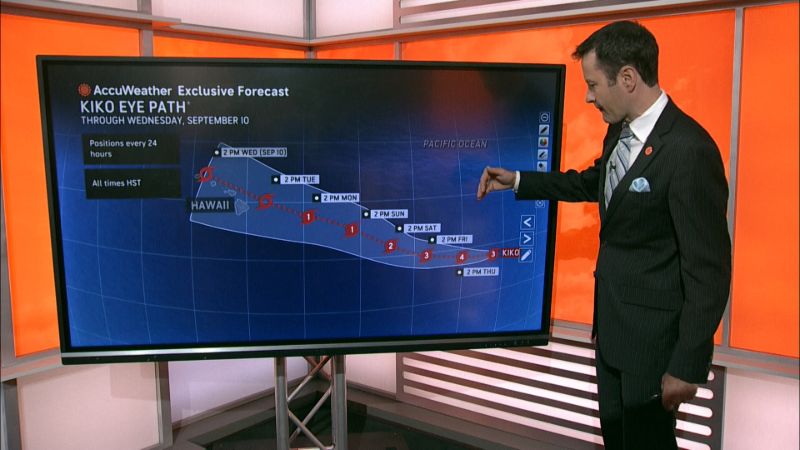
Another system in the Pacific, Hurricane Kiko, was headed toward the Hawaiian Islands from the east as a major Category 4 cyclone as of the morning of Sept. 4.
Storm tracker: Tracking path of Tropical Storm Lorena
This forecast track shows the most likely path of the center of the storm. It does not illustrate the full width of the storm or its impacts, and the center of the storm is likely to travel outside the cone up to 33% of the time.
Tropical Storm Lorena spaghetti models
Illustrations include an array of forecast tools and models, and not all are created equal. The hurricane center uses only the top four or five highest-performing models to help make its forecasts.
NHC also tracking a tropical wave in the Atlantic
In the Atlantic, the hurricane center is keeping tabs on a tropical wave located over the eastern tropical Atlantic, several hundred miles west-southwest of the Cabo Verde islands.
Forecasters said the showers and thunderstorms associated with this wave have started to consolidate and become slightly better organized, and that environmental conditions are conducive for gradual development of this system during the next several days. A tropical depression is likely to form late this week or this weekend, forecasters said in a Sept. 4 advisory.
The hurricane center said the system is likely to move faster toward the west or west-northwest afterwards and reach the waters east of the Lesser Antilles by the middle of next week, with forecasters giving the system an 80% chance of formation through the next seven days.
How do hurricanes form?
Hurricanes are born in the tropics, above warm water. Clusters of thunderstorms can develop over the ocean when water temperatures exceed 80 degrees. If conditions are right, the clusters swirl into a storm known as a tropical wave or tropical depression.
A tropical depression becomes a named tropical storm once its sustained wind speeds reach 39 mph. When its winds reach 74 mph, the storm officially becomes a hurricane.
Prepare now for hurricanes
Delaying potentially lifesaving preparations could mean waiting until it’s too late. “Get your disaster supplies while the shelves are still stocked, and get that insurance checkup early, as flood insurance requires a 30-day waiting period,” the National Oceanic and Atmospheric Administration recommends.
- Develop an evacuation plan. If you are at risk from hurricanes, you need an evacuation plan. Now is the time to begin planning where you would go and how you would get there.
- Assemble disaster supplies. Whether you’re evacuating or sheltering in place, you’re going to need supplies not just to get through the storm but for a possibly lengthy aftermath, NOAA said.
- Get an insurance checkup and document your possessions. Contact your insurance company or agent now and ask for an insurance checkup to make sure you have enough insurance to repair or even replace your home and belongings. Remember, home and renters insurance don’t cover flooding, so you’ll need a separate policy for those. Flood insurance is available through your company, agent or the National Flood Insurance Program. Act now, because flood insurance requires a 30-day waiting period.
- Create a family communication plan. NOAA says you should take the time now to write down a hurricane plan and share it with your family. Determine family meeting places and make sure to include an out-of-town location in case of evacuation.
- Strengthen your home. Now is the time to improve your home’s ability to withstand hurricanes. Trim trees and install storm shutters, accordion shutters, and impact glass; seal outside wall openings.
Gabe Hauari is a national trending news reporter at USA TODAY. You can follow him on X @GabeHauari or email him at Gdhauari@gannett.com.


Related Posts

Stay Informed With the Latest & Most Important News
Previous Post
Next Post


Advertisement


